


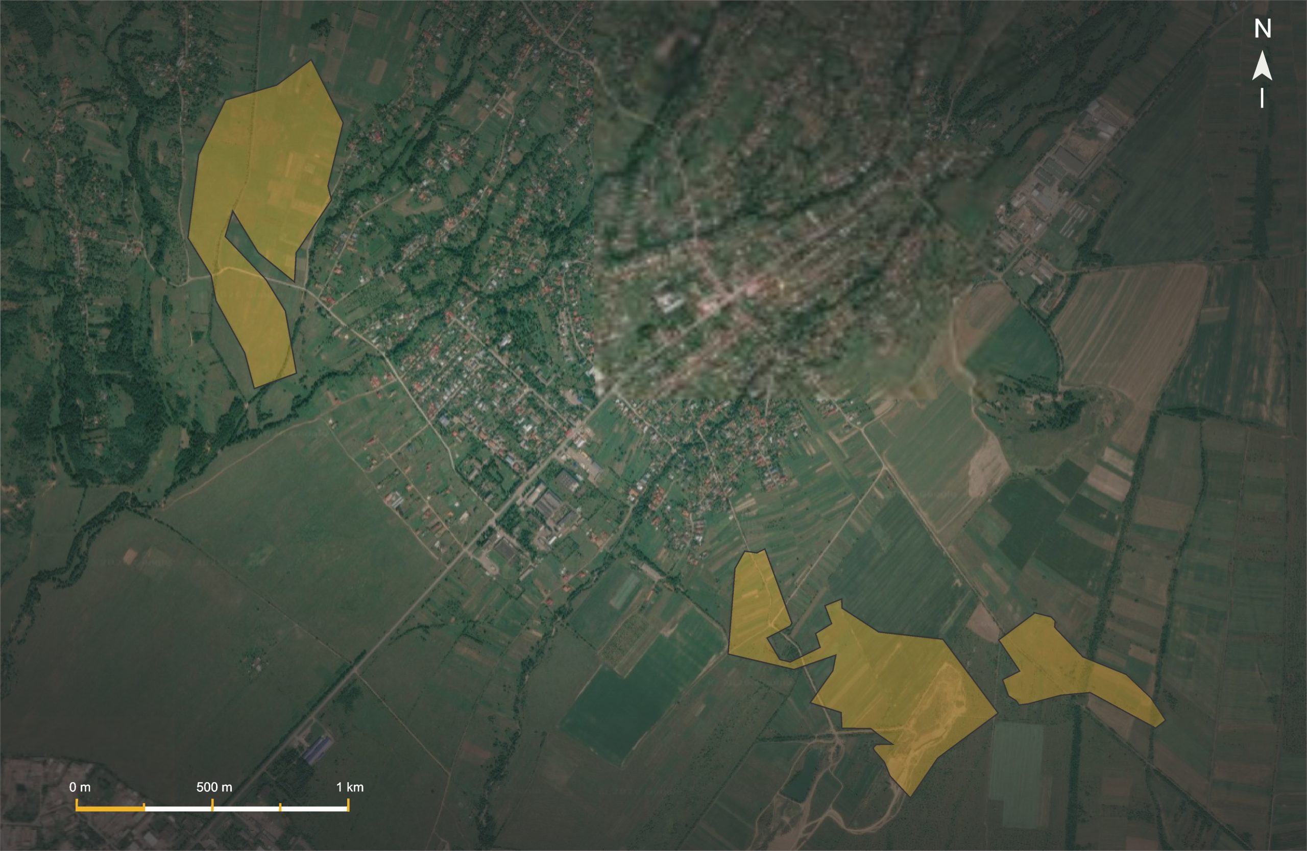
General information
- Subsoil user
- LLC “Lignit+”
- Deposit name
- Ilnytsia deposit
- Location
- Zakarpattia Oblast
- Mineral resource
- Lignite
- Special permit number
- №1672 від 17.11.1998
- Special permit valid until
- 29.09.2042
- Purpose of subsoil use
- Extraction of mineral resources
- Licensed area
- 87 ha
- Area distribution by sections
- “Kar’yerna” sector — 46.9 ha; “Kreminna” sector — 40.1 ha.
Reserves
Reserves under the SRC protocol
Of these, for the “Karierna” section
Of these, for the “Kreminna” section
Reserves as of 01.01.2026
Mineral quality
Classification according to DSTU 3472:2015: grade B, class 03, category 0, type 40, subtype 10 — B.2B.2BV.
Average ash content:
Seam I — 26.2%, ranging from 9.7% to 40.0%;
Seam II — 28.0%, ranging from 8.4% to 38.1%;
Seam IV — 24.8%, ranging from 16.2% to 40.7%;
Seam V — 26.6%, ranging from 17.2% to 37.5%.
Lower heating value:
Seam I — 2,390–2,461 kcal/kg;
Seam II — 2,360–2,400 kcal/kg;
Seam IV — 1,932–2,237 kcal/kg;
Seam V — 1,977–2,420 kcal/kg.
Radiological control: does not exceed 340 Bq/kg, corresponding to Class I use of the raw material.
Geological characteristics
Structural setting: Chop Depression, Ilnytsia Syncline.
Bedding: monoclinal, dipping south and southwest at angles of up to 5°.
“Karierna” Section
Mineral resource: the thickness of Seam I ranges from 0.1 to 2.8 m, while that of Seam II ranges from 0.7 to 2.5 m. Seam II occurs at a depth of 7.6–20.4 m.
Overburden: Seam I is overlain by alluvial gravel-and-pebble deposits with an average thickness of 7.9 m. The interval between Seams I and II consists mainly of argillite-like clays, tuffites, siltstones and sands, with a thickness of 3–10 m.
“Kreminna” Section
Mineral resource: Seam IV occurs at a depth of 0–36 m and, across approximately 80% of the area, at depths of up to 20 m. Its thickness ranges from 0.4 to 1.95 m, averaging 1.25 m. Seam V occurs at a depth of 4.75–35.0 m; its thickness ranges from 1.08 to 2.64 m, averaging 1.52 m.
Overburden: Seam IV is overlain by alluvial-deluvial loams, boulder-and-pebble formations and GRSh deposits, with a thickness of 3.0–13.8 m. Seam V is overlain by clays and argillites, with lesser amounts of siltstones, sands and tuffites.
Mining and hydrogeological conditions
Overburden characteristics
“Karierna” Section
Above Seam I, the overburden consists of alluvial gravel-and-pebble deposits with an average thickness of 7.9 m. The interval between Seams I and II consists mainly of argillite-like clays, tuffites, siltstones and sands, with a thickness of 3–10 m.
“Kreminna” Section
Seam IV is overlain by alluvial-deluvial loams, boulder-and-pebble formations and a gravel-sand mixture, with a thickness of 3.0–13.8 m.
Seam V is overlain by clays and argillites, with lesser amounts of siltstones, sands and tuffites.
Overburden volumes
“Karierna” Section
Seam I: overburden volume — 557.40 thousand m³; stripping ratio — 5.69 m³/t.
Seam II: overburden volume — 4,917.87 thousand m³; stripping ratio — 10.30 m³/t.
Total for the section: 5,475.28 thousand m³; stripping ratio — 9.52 m³/t.
“Kreminna” Section
Seam IV: overburden volume — 4,765.57 thousand m³; stripping ratio — 13.39 m³/t.
Seam V: overburden volume — 2,160.80 thousand m³; stripping ratio — 8.22 m³/t.
Total for the section: 6,926.37 thousand m³; stripping ratio — 11.19 m³/t.
Total overburden volume: 12,401.65 thousand m³; average stripping ratio — 10.38 m³/t.
Aquifers
The hydrogeological conditions of the Ilnytsia deposit are complex. Aquifers associated with weakly cemented and loose sands, tuffites, tuffs, sandstones, and andesites occur in the roof and floor of the coal seams. The aquifers are split and locally isolated; the most water-bearing rocks are sands and tuffs.
Within the deposit, an over-seam alluvial aquifer and aquifers associated with the coal seams have been identified. At the “Kar’yerna” sector, the over-seam alluvial aquifer, the under-seam aquifer of Seam I, and the over-seam aquifers of Seam II are distinguished. At the “Kreminna” sector, the over-seam alluvial aquifer, the over-seam aquifers of Seams IV and V, and the under-seam aquifer of Seam V are identified.
Water inflow, drainage and dewatering
The maximum predicted water inflow into the quarry is 75 m³/h. To collect water in the lower part of the pit floor, a drainage sump with drainage ditches is provided. Water pumping is carried out by two D320-50 pumps with automatic turning on and off based on level sensor readings.
The pumped water is delivered via a pipeline to a settling pond with a capacity of 1,200 m³. The treatment of quarry water from suspended solids and petroleum products takes place in two stages: preliminary settling in the sump and subsequent purification in the settling pond. After treatment, the water is discharged into the local hydrographic network, and part of it is used for technical needs. Laboratory quality control of return water and periodic cleaning of the settling pond from accumulated sediment are provided.
Production facilities
○ Excavator: HITACHI ZX 250.
○ Process transport provided for in the project: KamAZ-5511 dump trucks with a capacity of 10 tons.
○ Crushing equipment: SMD-109, SMD-116, MD-320, DVZ‑1.
○ Screen: GIL-32.
○ Conveyors: V‑550, inventory Nos. 6–10.
○ High-voltage equipment: KPT-105, ZPT-106, PL-10.
Permitting documentation
- Mining allotment
- Проєкт розробки та рекультивації родовища
- Environmental impact assessment conclusion
- Special water use permit
- Mining operations permit
- Permit for operation of electrical equipment above 1,000 V
- Permit for operation of crushing and screening equipment
- Mine surveying permit
- Air pollutant emissions permit
- Land use documentation
Mining lease approved for an area of 58.0 ha.
Mining and land reclamation project developed and approved in 2021.
Environmental Impact Assessment (EIA) decision — positive.
Land plot information
To date, land plots with an area of 3.0809 ha (cadastral number 2121984500:07:001:0069) and 0.5219 ha (cadastral number 2121984500:07:001:0070) have been successfully registered, following the permit granted by the Ilnytsia Village Council to draft land management plans in accordance with the Land Code and the Subsoil Code of Ukraine. In addition, the registration of a prospective 17.0 ha land plot (cadastral number 2121984500:07:001:0185) has been secured, laying the foundation for the next stage of deposit development and obtaining permission to remove the fertile soil layer.
Sale terms
- Object status
- Available for sale
- Price
- за запитом
Object materials
Download PDFContact information
For detailed information, sales terms, and access to documentation, please contact the Institute of Geology:
+38 (067) 286–84–14
[email protected]